Click on this link (if you want) to see the draft development of this project. There is a lot more in here than what I could include for the submitted assignment. If this was my job for the County, I'd have my work cut out for me, and they (the County) wouldn't like me very much.
Enjoy!
https://docs.google.com/document/d/18vuWZ3QcOTdLTmcGgdqgbRfmRp5XSLgfkmHkmUh4664/pub
Richardson Lane Watershed
Richardson Lane Watershed
Monday, December 14, 2015
Friends of the Banister Watershed Management Plan Guidance for the Southern Virginia Piedmont
Please click on the link to access the:
https://docs.google.com/document/d/1SUKnWsa7-lLy8n5w2mWZo5nuzbw4QZkAwPooTnbAzJU/pub
Banister River Watershed Management Plan
Development Protocol for Watershed Management Plans in Southern Virginia Piedmont
CASE STUDY: Pittsylvania Countyhttps://docs.google.com/document/d/1SUKnWsa7-lLy8n5w2mWZo5nuzbw4QZkAwPooTnbAzJU/pub
Watershed Assessment
The Richardson Lane Watershed is located in the Sandy Creek Watershed. Sandy Creek is a tributary of the Lower Banister River. As I progressed through my watershed studies, it became apparent that the Upper and portions of the Lower Banister River are under-valued and almost ignored by the community and the local government. I shifted my studies to the development of a Watershed Management Plan for the Banister River, specifically in Pittsylvania County. The following blog posts will include the draft documents I've created in the pursuit of developing such a plan.
Ultimately a Watershed Management Plan cannot be created alone. It must be a living document created by the community. With that in mind, I've created a presentation by the mock river group, Friends of the Banister. The presentation identifies what a watershed management plan is and why it's important. I've also created a draft of a watershed management plan guide specifically for the Southern Virginia Piedmont. As part of that document, a Fact Sheet has been created to promote and advertise the need for a watershed management plan in Pittsylvania County.
Finally, the final post is a messy run-on thought process as I went through the information found and my thoughts on specific sections. By reading that document, you might see just how involved a project like this can develop. All we need is people who want to dive in. Enjoy!
Please read through the following posts and contact me with any questions or comments. You can comment on the blog posts or email me at brianaleebill@gmail.com.
Sunday, December 6, 2015
"A win for our local rivers and stream, communities and economy"
"Another nail in the coffin" states Jack Dunavant, chairman of the We the People of Virgnia quality-of-life organization and 20-year member of the Halifax Town Council.
Looks like Virginia Uranium will not be allowed to drill for uranium or file suit against the Commonwealth of Virginia for upholding the moratorium on uranium mining. Read the story about the Federal Uranium Lawsuit tossed out of court. "River groups applaud dismissal of suit," states the Danville Register and Bee.
http://www.godanriver.com/news/danville/judge-grants-motion-to-dismiss-federal-lawsuit-on-uranium-mining/article_8f31b4da-990c-11e5-bf6c-a384e68ee918.html
Friday, November 20, 2015

Friday, November 6, 2015
Dam Removal Blog by Appalachian Voices
The Dan River is littered with dams. Some have been removed, others have not. Some are still in debate.
What do you think?
Read on for some insight:
Wednesday, October 28, 2015
The Feds Do Have Brains! Read on...
Just released: A new memorandum directing Federal agencies to factor the value of ecosystem services into Federal planning and decision-making.
https://www.whitehouse.gov/blog/2015/10/07/incorporating-natural-infrastructure-and-ecosystem-services-federal-decision-making
Now if we can the states to take this on...
https://www.whitehouse.gov/blog/2015/10/07/incorporating-natural-infrastructure-and-ecosystem-services-federal-decision-making
Now if we can the states to take this on...
Monday, October 26, 2015
Sunday, October 25, 2015
River District Festival Findings
One fine weekend I went to the River District Festival in Danville, VA. The Dan River flows through the city, and even then, outsiders don't know there is a river through the city or why Danville is named Danville. There are some folks out there trying the educate people about their watershed and the importance of protecting our waterways. The local rotary club was at the festival handing out this information. Pretty cool stuff!


Extra Learning Modules, EPA Watershed Information, Great Resource
The EPA has a pretty interesting web module program for a little additional learning.
The EPA's Watershed Academy's Distance Learning Program, or Watershed Academy Web is a Web site that offers a variety of self-paced training modules that represent a basic and broad introduction to the watershed management field. The modules are organized by the six themes listed above. Modules vary in the time they take to complete, from ½ hour to 2 hours (EPA http://cfpub.epa.gov/watertrain/index.cfm.)
http://cfpub.epa.gov/watertrain/index.cfm
Monday, October 12, 2015
Sunday, October 4, 2015
Watershed Protocol Selection
Friends of the Banister Watershed Management Plan
Watershed Management in the Piedmont
As my watershed protocol selection, I've elected to, attempt to, develop a Watershed Management Plan for the Banister River. My education and profession has allowed me to be pretty familiar with the suggested protocols listed for this class. In an attempt to try something new, I'm looking into the protocols of watershed planning.
I've found a nifty document by the Virginia Department of Conservation and Recreation (DCR) that focuses on watershed management in Virginia. This document can be found at:
http://www.dcr.virginia.gov/soil_and_water/documents/wshedguideb2b.pdf
My plan is to dissect this document and make it applicable to Southern Virginia Piedmont localities, specifically Pittsylvania County and the Banister River watershed.
My micro-watershed, the Richardson Lane Watershed, is in the Banister River Watershed and will provide a nice starting point for investigating any monitoring techniques, or basic data collection that may be needed.
As I progress through this process I will post interesting tid-bits on this blog. The body of the work is in google docs. If anyone is interested in following along, just click on this link:
https://docs.google.com/document/d/18vuWZ3QcOTdLTmcGgdqgbRfmRp5XSLgfkmHkmUh4664/pub
Thinking big here, but I'm hoping that this endeavor will either turn into an actual plan to be adopted by the Dan River Basin Association (DRBA) and/or the Pittsylvania County Board of Supervisors. Perhaps Friends of the Banister can be an actual subsidiary chapter to DRBA. This will not happen in the course of this class, but perhaps through the course of my graduate program. If a plan is not adopted, I can at least use what I've learned, and my mock management plan as a means to further my employment into the planning sector.
Saturday, October 3, 2015
What's up your stream?
We should all try to know what is the condition of our upstream headwaters.
This stream segment was the discharge of a pond overflow and seepage from the pond dam.
As we moved further downstream, the water clarity cleared.
This condition is probably a result of high iron, but would be frightening to most people upon first inspection.


This stream segment was the discharge of a pond overflow and seepage from the pond dam.
As we moved further downstream, the water clarity cleared.
This condition is probably a result of high iron, but would be frightening to most people upon first inspection.


Friday, October 2, 2015
Head Deep in Field Work
Our week long adventure along Morrow Creek and its tributary led us deeper and deeper into the waters and vegetation.
 |
| Photo by: Briana Bill |
 |
| Photo by: Briana Bill |
 |
| Photo by: Briana Bill Surrounded and head deep in impatiens capensis (jewelweed) |
 |
| Photo by: Briana Bill Head deep in puerarua lobata (kudzu) |
 |
| Photo by: Briana Bill When Kudzu rules the earth: "Ahhhhh!" |
Thursday, October 1, 2015
Knee Deep in Field Work
I get the chance to walk a lot of different watersheds. It's of great value to observe the differences, and the similarities.
When observing a watershed, we must take time to stop and smell the flowers, or talk to the frogs, and ooh and ah over the mushrooms.
Last week we were knee deep in field work. We were visiting the Morrow Creek watershed in Rutherford County, North Carolina. At the time, the watershed was experiencing a severe drought. Streams were dry, or very low. Luckily, the drought may soon be over...
Here are some photos from my days walking along Morrow Creek and it's tributaries. Morrow Creek is a tributary to the Broad River. It's all the little things that make the day interesting.
 |
| Photo by: Briana Bill apatelodes torrefacta (Spotted Apatelode) |
 |
| Photo by: Briana Bill |
 |
| Photo by: Briana Bill euonymus americanus (strawberry bush, hearts-a-burstin') |
 |
| Photo by: Briana Bill |
 |
| Photo by: Briana Bill chelone glabra (turtlehead) |
 |
| Photo by: Briana Bill commelina communis (asiatic dayflower) |
 |
| Photo by: Briana Bill lithobates palustris (pickerel frog) |
 |
| Photo by: Briana Bill lobelia kalmii (brook lobelia) |
 |
| Photo by: Briana Bill |
Wednesday, September 30, 2015
Watershed Walk
This past weekend the rain wouldn't quit. It let up, but drizzled on.
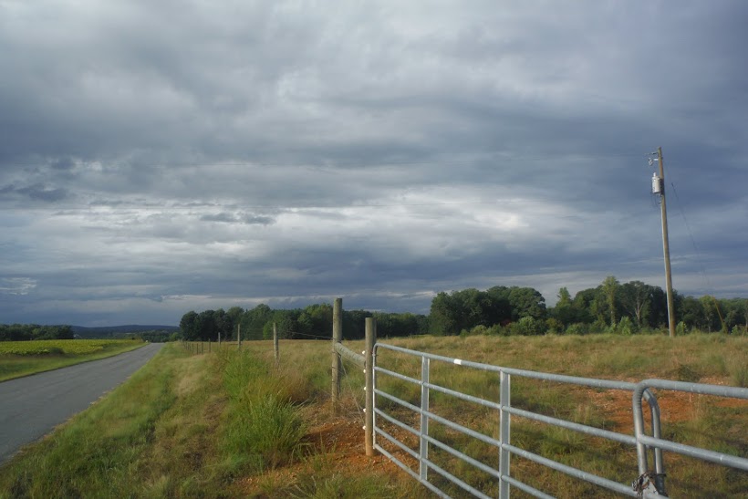
With so much rain and runoff, I thought it be a great day to check out the Richardson Lane Watershed and see what was happening with water levels and what kind of conditions the local runoff was in.
We explored the middle to southeastern portion of Tributary East. The goal was to reach the headwaters, but past logging and the thick under story prevented us from going all the way.
 |
| Photo by: Briana Bill The water is up! |
 |
| Photo by: Briana Bill
Deer sign in the watershed. His and hers scat. Buck to the left, doe to the right. We found an area with heavy foraging and a bedding area.
|
 |
| Photo by: Briana Bill A deer rub near the bedding area. |
 |
| Photo by: Briana Bill We traveled south along the stream bank and found this little waterfall. |
 |
| Photo by: Briana Bill |
 |
| Photo by: Briana Bill
As we traveled upstream, the under-story changed. The stream bank became thicker with smaller diameter trees and shrubs. The herbaceous layer was much thicker.
|
 |
| Photo by: Briana Bill
Further upstream the stream narrowed and became overgrown with vegetation and lots of brambles. It became difficult to maneuver through the underbrush. It appears this messy riparian zone is a result of past logging. The clearcut was taken all the way to the stream bank. There was no buffer provided by the logging and the result is overgrowth of vegetation. It is a typical practice in this area to clear cut right through the headwater streams as they are not incised and don't provide much of an obstacle.
|
 |
| Photo by: Briana Bill
We left the stream to go around and try to find the headwaters further upstream. As we traversed the hillside, we came across a very large beech tree, with a very small praying mantis attempting to scale the vertical trunk.
|
 |
| Photo by: Troy Shelton While not a monster, this is a large tree for this watershed. It was very tall. |
 |
| Photo by: Troy Shelton
We hiked up to an up-gradient tobacco field. At the edge of the field were large rocks that had been removed from the field years ago. They were stacked up in a row.
|
 |
| Photo by: Briana Bill At the forest edge, over looking the tobacco field. |
 |
| Photo by: Briana Bill
While runoff was occurring at this field, the vegetated roads and forested buffers provided good erosion control. This was the worst spot at the field's edge.
|
 |
| Photo by: Briana Bill
We could not follow the stream through the vegetation and stopped left of this photograph. The stream entered a pasture and is evident by the line of regrowth of trees and saplings.
|
 |
| Photo by: Briana Bill
The pasture is maintained to provide a forested stream buffer. The buffer is thick enough that the resident cattle avoid the stream. The farmer also provides a watering trough to discourage the cattle from the stream. The regrowth of trees outlines the general boundary of the headwaters.
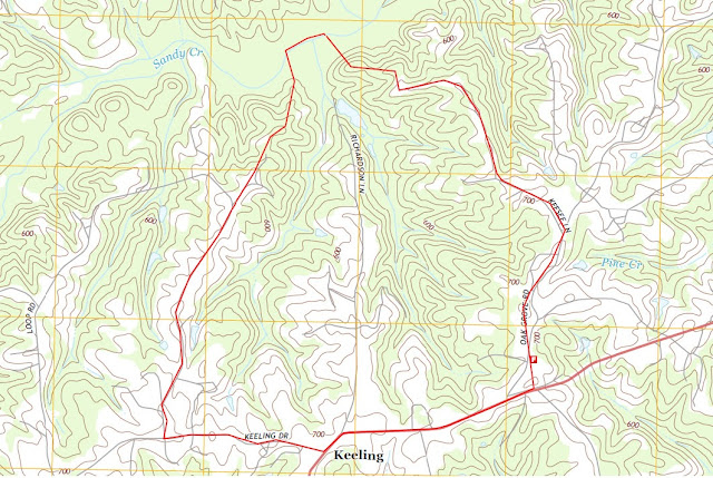
Watershed Walk Route
|
Google Maps 2015
Tuesday, September 29, 2015
Monday, September 28, 2015
Beautiful Invasive Species of Virginia
Enjoy this presentation on Beautiful Invasive Species!
Not all that glitters is gold.
Be sure to download the power point for proper presentation.
or click on this link:
https://www.scribd.com/doc/283054415/Beautiful-Invasive-Species
Not all that glitters is gold.
Be sure to download the power point for proper presentation.
or click on this link:
https://www.scribd.com/doc/283054415/Beautiful-Invasive-Species
Upcoming Seminar for folks studying watersheds in the Chesapeake Bay area!
Hey Folks,
I received this information regarding some upcoming training. This seminar is free to attend and may be of interest if you are in the area.
The Chesapeake Bay National Estuarine Research Reserve in Virginia is pleased to offer the following:
Forests for the Bay
Join us on Wednesday, October 21, 2015 to hear Craig Highfield and Jenny McGarvey, of the Alliance for the Chesapeake Bay – Forests for the Bay Program, talk about the ecological and resource benefits of sustainable forest management. Healthy forests, and healthy riparian buffers support water quality and watershed sustainability. Neil Clark, of the Virginia Cooperative Extension, Southeast Area will talk about Virginians and their forests! (An agenda is attached.)
WHEN: Wednesday, October 21, 2015, 9:00 AM to 12:00 Noon
WHERE: In the McHugh Auditorium / Waterman’s Hall, in Gloucester Point, Virginia, on the campus of the Virginia Institute of Marine Science.
REGISTRATION: There is no charge for this workshop, but you must pre-register. Please send an email with the following information: name, email address, work affiliation, telephone number, to Sandra Erdle – at syerdle@vims.edu, BY Friday, October 16, 2015. I will send a confirmation email when I receive your information.
Wednesday, October 21st, 2015
McHugh Auditorium /
Waterman’s Hall, Virginia Institute of Marine Science
Gloucester Point
9:00 – 9:10 Welcome and Overview
Sandra Erdle, Coastal Training Program Coordinator,
Chesapeake Bay National Estuarine Research Reserve
9:10 – 9:55 Virginians
and their forests –
what forests are providing for Virginians and what Virginians are doing for
their forests.
Neil Clark, Agent, Virginia
Cooperative Extension, Southeast Area
9:55 – 10:40 Forests and water - A discussion on the essential role forests
provide to the function of Virginia’s streams, rivers and the Chesapeake Bay. Craig Highfield, Alliance for the
Chesapeake Bay
10:40 – 10:55 Break
10:55 – 11:30 Ecosystem
markets – an
overview of Virginia’s nutrient trading program and opportunities it presents
for Virginia’s rural landowners and
forest restoration followed by a discussion of two current nutrient trading projects
initiated by the Alliance
Jenny McGarvey – Alliance for the Chesapeake Bay
11:30 – 12:00 Conservation
tools on the web – Demonstration of new innovative tools available free for
landowners and resource professionals. Craig Highfield & Jenny McGarvey
Friday, September 25, 2015
Global Sustainability?
What a concept. This Pope is an interesting fella. If we stop to think about sustainability of the earth and all of her inhabitants, what might we change about the way we live? Are we willing to do it?

(http://www.democracynow.org/blog/2015/9/25/at_un_pope_blasts_selfish_and)
Speaking at the United Nations today, Pope Francis called on world leaders to protect the earth. He said, "In effect, a selfish and boundless thirst for power and material prosperity leads both to the misuse of available natural resources and to the exclusion of the weak and disadvantaged [...] The poorest are those who suffer most from such offenses, for three serious reasons: they are cast off by society, forced to live off what is discarded and suffer unjustly from the abuse of the environment. They are part of today’s widespread and quietly growing 'culture of waste (Democracy Now).'"
Retrieved from: http://www.democracynow.org/blog/2015/9/25/at_un_pope_blasts_selfish_and [webpage] on September 25, 2015.
Tuesday, September 22, 2015
Saturday, September 19, 2015
A day at work in the Banister River Watershed
I get to work all over the place.
This past week I spent my days in Halifax County.
This particular location was associated with a closed landfill.
Landfills are perhaps an overlooked resource. They are full of biodiversity, of you just take the time to look around.
I was in the Winn Creek watershed. This is part of the Terrible Creek watershed, which is part of the Banister River watershed.
I wasn't alone, check out my co-workers.


Okay, these two were weird. I thought the brown fuzball was a leaf. I bent down to check out the Saddleback caterpillar and the brown leaf unfolded and walked away. It's a Monkey Slug Caterpillar. Quite a site.
Friday, September 18, 2015
International Rivers
International Rivers is an interesting website. I encourage you to check it out:
http://www.internationalrivers.org/
I really like this part of their definition of a watershed:
"A watershed is a web of life. The life it supports is interconnected, meaning every creature and plant depends on other creatures and plants in the watershed for sustenance. If the whole watershed is like our bodies, then rivers are like our veins – coursing with life and crucial to sustaining it (International Rivers)."
International Rivers. (2015). Rivers Basin Basics. Retrieved from: http://www.internationalrivers.org/river-basin-basics
Thursday, September 17, 2015
HUC or Watershed?
When asked to identify the watershed I was going to study, I immediately thought, "Oh, what's the HUC code and I can go from there." In my line of work, HUC codes really mean something to regulators. To me, they can be a bit hard to find, and while they are helpful for permits and identifying the watershed a project is located in, I wasn't sure what the big deal was. Regardless, I looked up the 8-digit, the 10-digit and 12-digit HUC codes for the Richardson Lane Watershed.
Looking at HUC codes in a manner than actually meant something to me was enlightening. Ah ha! The 8-digit code is a broad identifier: We are in the Banister River Hydrologic Unit.

The 10-digit code is a bit more defined: We are in the Sandy Creek Hydrologic Unit.

The 12-digit code is even more specific: We are in the Upper Sandy Creek Hydrologic Unit.

In Virginia, the Department of Conservation and Recreation (DCR) has a great website that helps you find your HUC code by latitude/longitude, an address, searching a map, etc.
http://dswcapps.dcr.virginia.gov/htdocs/maps/HUExplorer.htm
Wait a minute. I thought we were talking about watersheds. What is a hydrologic unit?
On their website, DCR defines a watershed and a hydrologic unit and the differences between the two. According to DCR, "a true watershed is an area of land and water defined by a boundary such that all surface drainage within the boundary converges to a single point. This point of convergence is usually the exit point, where the collected waters leave the watershed. There are, however, watersheds out of which no water flows.
In contrast, hydrologic units are drainage areas that are delineated so as to nest into a multi-level hierarchical drainage system. Aside from the surface waters that are collected within the boundary of a hydrologic unit, it may also accept water from one or more points outside of the unit’s boundary. The tidal portion of the James River is a good example. It can be a hydrologic unit but not a watershed, because water enters this unit from both the non-tidal (Piedmont) James River at Richmond and the Appomattox River at Hopewell. Additionally, hydrologic units may include associated surface areas whose drainages do not connect, thus resulting in multiple outlet points. This is usually the case with coastal frontage units such as those containing multiple outlets to the Chesapeake Bay or Atlantic Ocean (DCR)."
So HUCs are a great way to quickly find your watershed, but beware, HUCs may contain more than just the watersheds associated with a river system.
Looking at HUC codes in a manner than actually meant something to me was enlightening. Ah ha! The 8-digit code is a broad identifier: We are in the Banister River Hydrologic Unit.
The 10-digit code is a bit more defined: We are in the Sandy Creek Hydrologic Unit.
The 12-digit code is even more specific: We are in the Upper Sandy Creek Hydrologic Unit.
In Virginia, the Department of Conservation and Recreation (DCR) has a great website that helps you find your HUC code by latitude/longitude, an address, searching a map, etc.
http://dswcapps.dcr.virginia.gov/htdocs/maps/HUExplorer.htm
Wait a minute. I thought we were talking about watersheds. What is a hydrologic unit?
In contrast, hydrologic units are drainage areas that are delineated so as to nest into a multi-level hierarchical drainage system. Aside from the surface waters that are collected within the boundary of a hydrologic unit, it may also accept water from one or more points outside of the unit’s boundary. The tidal portion of the James River is a good example. It can be a hydrologic unit but not a watershed, because water enters this unit from both the non-tidal (Piedmont) James River at Richmond and the Appomattox River at Hopewell. Additionally, hydrologic units may include associated surface areas whose drainages do not connect, thus resulting in multiple outlet points. This is usually the case with coastal frontage units such as those containing multiple outlets to the Chesapeake Bay or Atlantic Ocean (DCR)."
So HUCs are a great way to quickly find your watershed, but beware, HUCs may contain more than just the watersheds associated with a river system.
Virginia Department of Conservation and Recreation (DCR). (2015). Hydrologic Unit Geography. Retreived from: http://www.dcr.virginia.gov/soil_and_water/hu.shtml
Friday, September 4, 2015
Richardson Lane Watershed, Upper Sandy Creek
I've selected two unnamed tributaries of the Upper Sandy Creek Watershed to study for the Watershed Systems Stewardship class. For the purpose of this blog, I've temporarily named this micro-watershed the Richardson Lane Watershed.
Richardson Lane Watershed
Location: Richardson Lane, Keeling, Virginia 24566
Lat/Long: 36°43’46.12”N / 79°17’11.81”W
Highlighted in red on the USGS map is the topographic boundaries of the proposed study area. You'll note there are two tributaries on each side of Richardson Lane. For the purpose of this evaluation, the tributary to the east of Richardson Lane will be Tributary East (Trib.E) and the tributary to the west of Richardson Lane will be Tributary West (Trib.W).
We start small and grow larger in contribution to larger watersheds:
I reside along Richardson Lane, in Keeling, Virginia. Keeling is in Pittsylvania County in Southern Virginia, near the city of Danville.
http://pittsylvaniacountyva.gov/.
I have been part of this tiny community long enough to feel the desire to know it better. When we moved here, we were surrounded by forest; a little cabin tucked away in the woods. Our forest was further surrounded by even more forest and farmland.
A year after moving in, we noticed strange survey ribbons along the property boundary and an informative neighbor notified us of a pending logging operation. The forest north of our property was completely removed and we were left with a view of a 40 acre clear cut.
I'm an environmental scientist by trade and immediately noticed the lack of stream buffers and erosion control. I said to myself, "That would make an interesting study. I wonder what kind of actual impact that is having on the stream."
Not long after, the familiar noise of the logging machines rumbled to the west.
In addition to forest, we are bound by a 140 acre farm. This farm is subject to a variety of uses, one of which is tobacco farming. In 2015, the acreage of tobacco fields increased, as did the obvious sediment runoff into the nearby waterways.
The events and land use along Richardson Lane is not unique. It's quite common throughout southern Virginia. By understanding my micro-watershed and the effects of its land use, I am hoping I can educate the local community of steps they can take to reduce erosion and improve land management.
Richardson Lane Watershed
Location: Richardson Lane, Keeling, Virginia 24566
Lat/Long: 36°43’46.12”N / 79°17’11.81”W
 |
| USGS Quadrangle: Blairs, VA 2013 |
We start small and grow larger in contribution to larger watersheds:
Upper Sandy Creek » Sandy Creek » Banister River » Dan River » Roanoke River
 |
| Source: US Geological Survey (USGS), Effects of Flood Control and Other Reservoir Operations on the Water Quality of the Lower Roanoke River, North Carolina (Scientific Investigations Report 2012–5101) |
I reside along Richardson Lane, in Keeling, Virginia. Keeling is in Pittsylvania County in Southern Virginia, near the city of Danville.
http://pittsylvaniacountyva.gov/.
I have been part of this tiny community long enough to feel the desire to know it better. When we moved here, we were surrounded by forest; a little cabin tucked away in the woods. Our forest was further surrounded by even more forest and farmland.
A year after moving in, we noticed strange survey ribbons along the property boundary and an informative neighbor notified us of a pending logging operation. The forest north of our property was completely removed and we were left with a view of a 40 acre clear cut.
I'm an environmental scientist by trade and immediately noticed the lack of stream buffers and erosion control. I said to myself, "That would make an interesting study. I wonder what kind of actual impact that is having on the stream."
Not long after, the familiar noise of the logging machines rumbled to the west.
In addition to forest, we are bound by a 140 acre farm. This farm is subject to a variety of uses, one of which is tobacco farming. In 2015, the acreage of tobacco fields increased, as did the obvious sediment runoff into the nearby waterways.
The events and land use along Richardson Lane is not unique. It's quite common throughout southern Virginia. By understanding my micro-watershed and the effects of its land use, I am hoping I can educate the local community of steps they can take to reduce erosion and improve land management.
Subscribe to:
Posts (Atom)